Hawaii (The Big Island) Maps and Orientation
(The Big Island, Hawaii - HI, USA)
The volcanic island of Hawaii is the largest of all the islands within this North American state, hence it being known as the 'Big Island'. Famous for its varied geography, which ranges from sandy beaches and desert areas, to rain forests and even volcanoes, the Big Island of Hawaii covers just over 4,000 square miles / 10,360 square kilometres and continues to expand, due to the active volcanoes of both Kilauea and Mauna Loa.
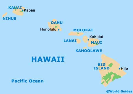
Within the Hawaiian archipelago, the Big Island remains the most southerly destination, with the island of
Maui lying directly to the north, and separated by the Alenuihaha Channel. In general, the Big Island can be divided into four main regions, East Hawaii, West Hawaii, Kohala (the northern area) and also Kau (the southern side).
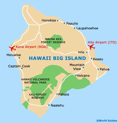
Maps and Orientation of the Island
The Kona Coast resides on the western side of Hawaii Island and this dry and very sunny spot is home to the large town of Kailua, with the area often being known as 'Kailua-Kona'. Located on the South Kona Coast is the Kealakekua Bay State Historical Park, where Captain Cook actually lost his life and this spot is marked with an obelisk. The part of Hawaii's Big Island is also known for its exceptional snorkelling conditions and easy to find on maps. North Kona is home to some rather beautiful beaches, the Kona Coast State Park and also the Hapuna Beach State Recreation Park.
Further north, the biggest resorts are clustered around Waikoloa, in the area known as the Big Island's South Kohala district. North Kohala marks the very north-westerly tip of Hawaii Island and is where you will find the Lapakahi State Historical Park. To see some truly wondrous island scenery and experience the beauty of the Waipio Valley, you will need to pay a visit to the Hamakua Coast, which resides at the very end of Highway 240. The county capital of Hilo city is also well known on the Big Island for its natural appeal and is home to a useful Visitors Bureau, here maps and brochures of popular walking tours are available.
Map of the United States

Islands of Hawaii Map
Map of Hawaii Big Island